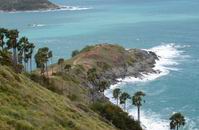
Promthep Cape
 'Prom'
is Thai for the Hindu 'Brahma' signifying purity, and 'Thep' means
'God'. Prom Thep is a headland stretching in to the sea and forming
the extreme south-end of Phuket. Promthep Cape (Laem Prom Thep)
has been a prominent feature for mariners since of early seafarers
from the sup-continent, remains of whose journey have been found
all along the Malay-peninsula's west coast. 'Prom'
is Thai for the Hindu 'Brahma' signifying purity, and 'Thep' means
'God'. Prom Thep is a headland stretching in to the sea and forming
the extreme south-end of Phuket. Promthep Cape (Laem Prom Thep)
has been a prominent feature for mariners since of early seafarers
from the sup-continent, remains of whose journey have been found
all along the Malay-peninsula's west coast.
From Rawai Beach turn right and go for 2 kilometers. The cape has
tall cliffs on the south, and was formerly called by local villagers
'Laem Jao' (The Gods' Cape). From the cliffs running down to the
boulders at the sea is the line of toddy palm trees. Emerald green
currents swirl in the water and breakers hurl themselves in vain
against the rocky point: it is one of Phulet's most inspiring vistas.
In the distance can be seen Gaew Island (Koh Gaew). From Promthep
Cape, which is the most beautiful place to catch Phuket's famous
sunset, a road leads northwest to Naiharn Beach.
Back to TOP
Kata View Point
From this Kata View Point (Jud Chom View Ka Ta)
can be seen the bays of Kata Noi, Kata, and Karon, and also Poo
Island (Koh Poo). It is one of the island's best views. A large
public sala, or shelter is there for visitors, and several vendors
sell food, drinks, and souvenirs in the area when the weather is
nice. The view point is between Kata Beach and Nai Harn Beach.
Back to TOP
Rang Hill
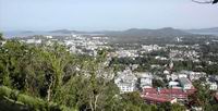 A
great view of Phuket Town, the southern part of the island, and
some of the offshore island, can be obtained by going to the top
of Rang Hill (Kao Rang), on the city's northwest. There are also
several restaurants featuring spectacular views of the city; a health
park for exercise enthusiasts, and a comfortable, expanse of grass
for picnickers at the top with a bronze statue of Phraya Ratsada
Nupradit the model Governor of Phuket during King Rama V's reign. A
great view of Phuket Town, the southern part of the island, and
some of the offshore island, can be obtained by going to the top
of Rang Hill (Kao Rang), on the city's northwest. There are also
several restaurants featuring spectacular views of the city; a health
park for exercise enthusiasts, and a comfortable, expanse of grass
for picnickers at the top with a bronze statue of Phraya Ratsada
Nupradit the model Governor of Phuket during King Rama V's reign.
Back to TOP
|

PHUKET Province
• Attractions
• Activities
• Festivals
• Hotels
• Local Food
• Restaurants
• Shopping
• Tours
• Getting There
• Getting Around
• General Info
• History
|