Phi Phi Islands
The name is derived from Malay, and the original
was 'Pulao Pi Ah Pi', where in 'Pulao' is the Malay word for island,
and 'Pi', pronounced with only a half p sound, was very close in
pronunciation to the English word be; the 'Ah' was eventually dropped,
so the name was said something like Bi Bi. Later the p was pronounced
with a stronger aspiration and the name became the Pi Pi we know
today (the h with which it is usually spelled is confusing and superfluous).
The name refers to the mangrove wood found there. Six islands are
in the group; Phi Phi Don Island, Phi Phi Ley Island, Biddah Nok
Island, Biddah Nai Island, Yung Island, and Maiphai Island; total
area is about 35 square kilometers. They were incorporated into
the national park in 1983. Some of the interesting places to visit
include:
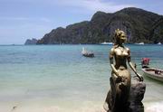
Phi Phi Don Island
 Phi
Phi Don Island (Koh Phi Phi Don) covers a total area of 28 square
kilometers: 8 kilometers in length and 3.5 at its broadest point.
At the north end is Tohng Cape (Laem Tohng) where there is a Chao
Ley, or sea gypsy village. These sea gypsies emigrated from Lipeh
Island in Tarutao National Park, near the border with Malaysia.
Diving at Tohng Cape is excellent, as it is also at Hua Rah Ket
to the extreme south. There are long beaches with rocks scattered
about. Two curving bays are especially beautiful: Ton Sai Bay
(Ao Ton Sai) and Loh Dalam Bay (Ao Loh Dalam). This is also
where accommodations and tourist services are found. Phi
Phi Don Island (Koh Phi Phi Don) covers a total area of 28 square
kilometers: 8 kilometers in length and 3.5 at its broadest point.
At the north end is Tohng Cape (Laem Tohng) where there is a Chao
Ley, or sea gypsy village. These sea gypsies emigrated from Lipeh
Island in Tarutao National Park, near the border with Malaysia.
Diving at Tohng Cape is excellent, as it is also at Hua Rah Ket
to the extreme south. There are long beaches with rocks scattered
about. Two curving bays are especially beautiful: Ton Sai Bay
(Ao Ton Sai) and Loh Dalam Bay (Ao Loh Dalam). This is also
where accommodations and tourist services are found.
Back to TOP
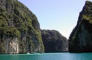
Phi Phi Ley Island
 Phi
Phi Ley Island (Koh Phi Phi Ley) is 6.6 square kilometers in
total area: 3 kilometers in length and 1 kilometer at its broadest
point. The Island is entirely limestone and steep cliffs rising
from the sea very nearly ring it. Surrounding waters average about
20 meters in depth, reaching 34 meters at the deepest point off
the Island's southern tip. Phi Phi Ley Island has several beautiful
bays: Pileh Bay (Ao Pi Leh), Maya Bay (Ao Ma Yah),
and Loh Samah Bay (Ao Loh Sa Mah); Pileh Bay is very nearly
enclosed by the limestone walls of the Island's cliffs, so that
the water appears almost to be an inland sea. On Phi Phi Ley's northeast
is the famous Viking Cave; this was renamed by H.M. Rama
IX when he visited it in 1972, Tahm Pya Nak, from the shape of a
particular boulder, which resembles in shape the head of the great
serpent of Buddhist legend, the Naga. It is a place much revered
by the local people who come there to collect the swift's nests
used to make Bird's Nest Soup, a Chinese delicacy. On the eastern
and southern walls of the cave are colored drawings dating from
historic times. There are of various boats: European, Arab, and
Chinese sailing ships; barques, motorboats, and steamships. It is
theorized that these pirates who paused in their travels from west
to east, sheltering in the cave to escape the monsoon winds, transfer
cargo, or make repairs. Phi
Phi Ley Island (Koh Phi Phi Ley) is 6.6 square kilometers in
total area: 3 kilometers in length and 1 kilometer at its broadest
point. The Island is entirely limestone and steep cliffs rising
from the sea very nearly ring it. Surrounding waters average about
20 meters in depth, reaching 34 meters at the deepest point off
the Island's southern tip. Phi Phi Ley Island has several beautiful
bays: Pileh Bay (Ao Pi Leh), Maya Bay (Ao Ma Yah),
and Loh Samah Bay (Ao Loh Sa Mah); Pileh Bay is very nearly
enclosed by the limestone walls of the Island's cliffs, so that
the water appears almost to be an inland sea. On Phi Phi Ley's northeast
is the famous Viking Cave; this was renamed by H.M. Rama
IX when he visited it in 1972, Tahm Pya Nak, from the shape of a
particular boulder, which resembles in shape the head of the great
serpent of Buddhist legend, the Naga. It is a place much revered
by the local people who come there to collect the swift's nests
used to make Bird's Nest Soup, a Chinese delicacy. On the eastern
and southern walls of the cave are colored drawings dating from
historic times. There are of various boats: European, Arab, and
Chinese sailing ships; barques, motorboats, and steamships. It is
theorized that these pirates who paused in their travels from west
to east, sheltering in the cave to escape the monsoon winds, transfer
cargo, or make repairs.
Back to TOP
Yung Island
Yung Island (Koh Yung) lies to the north
of Phi Phi Don Island. There is a rocky beach on the east side,
and a smaller stand of sand in a fold of the hill. Many beautiful
and various corals are found there.
Back to TOP
Maipai Island
Maiphai Island (Koh Mai Phai) lies also to the north of
Phi Phi Don, not far from Koh Yung. Sandy beaches are on the north
and east sides of the island. Broad coral reefs stretch away into
the south.
Back to TOP
Getting There
Travel to the Phi Phi Islands, tour operators in both Phuket and
Krabi provide transport and tour packages to this popular destination.
Regular boat service is available from Rassada Pier and many piers
on Sirey Island in Phuket and also Jao Fah pier in Krabi.
Back to TOP
|

Krabi Province
• Attractions
• Activities
• Festivals
• Hotels
• Local Food
• Restaurants
• Shopping
• Tours
• Getting There
• Getting Around
• General Info
• History
|